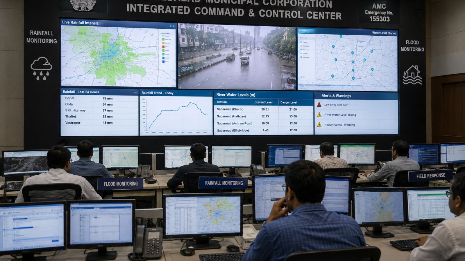
Ahmedabad Municipal Corporation (AMC) has introduced a new web based Integrated Modelling and Decision Support System designed to strengthen the city flood preparedness and improve monsoon management. Developed under the Government of India National Supercomputing Mission using High Performance Computing facilities at C DAC Pune, the platform is designed to provide advanced weather forecasting, waterlogging prediction, and climate risk monitoring across Ahmedabad. The initiative represents a major step toward technology driven urban disaster management. Instead of relying only on historical trends or manual assessments, the new system uses data driven modelling to identify vulnerable areas, forecast rainfall impacts, and support faster emergency response decisions. By combining weather forecasting, terrain analysis, and waterlogging intelligence, the platform aims to help city authorities prepare before flooding situations develop.
What Is the AMC Flood Prediction System
The newly launched Integrated Modelling and Decision Support System is a digital platform that combines weather forecasting, rainfall modelling, waterlogging prediction, and emergency planning tools into a single command system. Its primary objective is to provide authorities with early information about areas that may face flooding, drainage overload, or weather related disruptions. The platform offers detailed monitoring capabilities across Ahmedabad municipal wards and extends coverage beyond city limits to surrounding industrial and urban growth corridors. The system is designed not only for flood prediction but also for monitoring extreme weather conditions, heat related events, and air quality concerns.
Key Features of the AMC Flood Prediction System
| Feature | Description |
|---|---|
| Ward level forecasting | Localized predictions for all 51 municipal wards within Ahmedabad |
| High resolution weather modelling | Daily Accumulated Rainfall model with WRF engine at approximately 1.5 km resolution |
| 72 hour advance warning | Up to 72 hours advance notice for severe weather conditions |
| Regional monitoring | Coverage extending beyond city limits to Sanand, Dholka, Viramgam |
| Real time colour coded risk mapping | Dynamic visual maps for quick overview of conditions across the city |
| 3D terrain mapping | High resolution mapping to identify low lying areas where water naturally accumulates |
| Historical waterlogging analysis | Cross referencing rainfall forecasts with approximately 115 identified waterlogging bottlenecks |
How Vulnerable Areas Are Identified
One of the most innovative aspects of the platform is its ability to identify flood prone locations using multiple layers of data analysis.
- Real time colour coded risk mapping: The system uses colour coded indicators displayed on a centralized dashboard. As rainfall intensity changes, municipal officials can immediately see which wards require attention
- 3D terrain mapping technology: The platform utilizes high resolution three dimensional terrain mapping to identify low lying areas where water naturally accumulates by analyzing ground elevations and drainage patterns
- Historical waterlogging analysis: The system cross references rainfall forecasts with approximately 115 identified waterlogging bottlenecks across the city, with several locations concentrated in southern areas such as Maninagar, Behrampura, and Isanpur
How the System Improves Monsoon Preparedness
The value of a flood prediction system extends beyond forecasting. Its effectiveness depends on how authorities use the information to prepare resources and coordinate responses.
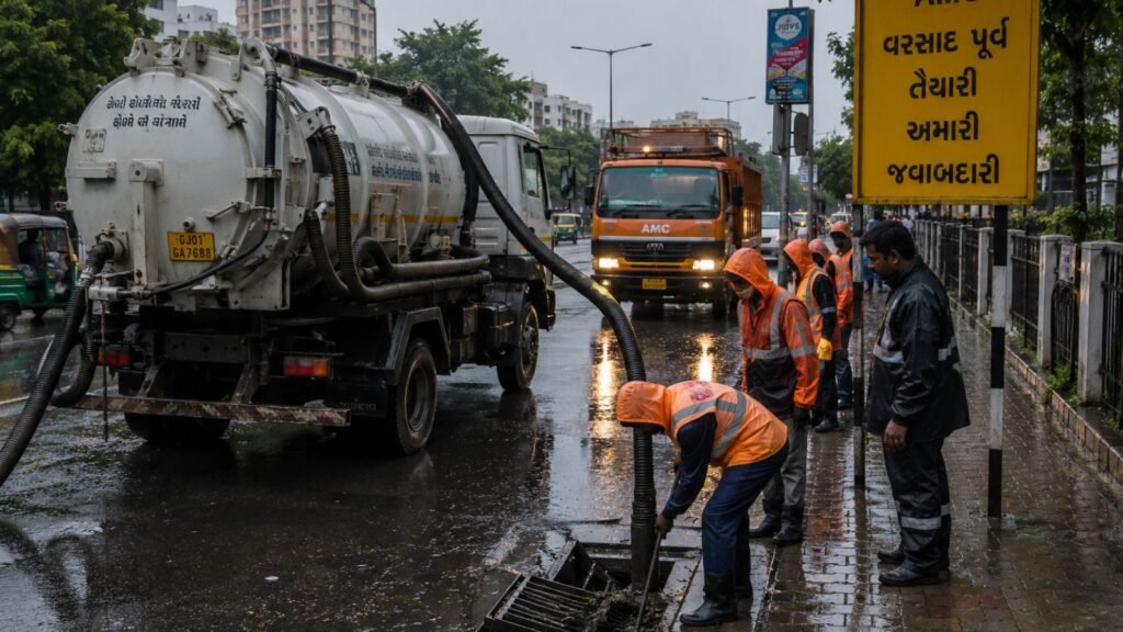
- Resource pre positioning: Advance forecasts allow municipal teams to deploy dewatering pumps, drainage maintenance teams, trash clearing equipment, and emergency rescue resources before flooding occurs
- More efficient resource allocation: Instead of distributing manpower evenly across the city, authorities can focus attention on areas identified as high risk
- Supporting existing infrastructure projects: The prediction platform complements ongoing drainage and flood mitigation projects including drainage network upgrades, new trunk drainage systems, eastern lake interlinking initiatives, and water management improvements in expanding urban zones
Improvements in Emergency Response Operations
The system is designed to support faster and more coordinated emergency actions.
| Emergency Response Feature | Benefit |
|---|---|
| Automated alert generation | When monitored conditions reach critical thresholds, platform automatically generates alerts and notifications for response teams |
| Unified control room operations | Officials can simultaneously monitor waterlogging conditions, Air Quality Index, weather forecasts, and wind pressure information |
| Standardized response procedures | System aligns automated alerts with established Standard Operating Procedures (SOPs) |
Benefits for Ahmedabad Residents
While the system is designed for municipal operations, citizens are expected to benefit directly from improved forecasting and emergency preparedness.
- Reduced traffic disruptions: Advance identification of high risk zones can help authorities issue advisories, reroute traffic, and manage congestion before roads become inaccessible
- Underpass safety alerts: The system can support warnings and advisories related to approximately 25 vulnerable underpasses
- Bilingual information access: Climate and weather information can be communicated in both Gujarati and English
- Air quality and health information: Residents may receive updates related to pollution dispersion patterns
Future Vision: Smart Flood Management in Ahmedabad
The newly launched platform is also designed as a foundation for future smart city initiatives.
- Digital twin integration: Future development plans include creating dynamic virtual city models using three dimensional spatial data to simulate runoff patterns and flooding scenarios
- Sponge city concepts: The platform may eventually support integration with sponge city infrastructure approaches including directing stormwater into urban gardens, green spaces, underground storage systems, and water retention areas
- Multi hazard climate monitoring: The long term goal extends beyond flood forecasting to include flood risks, heat stress conditions, air quality events, and climate related urban hazards
Why This Initiative Matters for Ahmedabad
Ahmedabad has experienced rapid urban expansion over the past decade. Increased construction activity, changing land use patterns, and growing population density have placed additional pressure on drainage systems and urban infrastructure. The AMC Flood Prediction System represents a shift toward predictive governance, where data and technology help authorities prepare for challenges before they become emergencies. By combining high resolution weather forecasting, historical waterlogging analysis, terrain mapping, and automated response tools, the platform aims to improve decision making and strengthen monsoon preparedness across the city. If implemented effectively, the system could help reduce flooding impacts, improve emergency coordination, and enhance public safety during future monsoon seasons.
Conclusion
The Ahmedabad Municipal Corporation Integrated Modelling and Decision Support System marks a significant advancement in urban flood management. With ward level forecasting, 72 hour advance warnings, 3D terrain analysis, automated alerts, and real time risk mapping, the platform provides a comprehensive approach to managing weather related challenges. Beyond flood prediction, the system lays the foundation for future smart city initiatives involving digital twins, climate monitoring, and intelligent emergency response networks. As Ahmedabad continues to grow, technology driven solutions like this could play an increasingly important role in protecting residents, improving infrastructure planning, and reducing the impact of extreme weather events.
Frequently Asked Questions
Q1. What is the AMC Flood Prediction System 2026
A1. It is a web based Integrated Modelling and Decision Support System developed under the National Supercomputing Mission using C DAC Pune HPC facilities to provide weather forecasting, waterlogging prediction, and climate risk monitoring across Ahmedabad.
Q2. What are the key features of the AMC Flood Prediction System
A2. Key features include ward level forecasting for 51 municipal wards, 72 hour advance warnings, 3D terrain mapping, real time colour coded risk mapping, and historical waterlogging analysis of approximately 115 identified bottlenecks.
Q3. How does the system help during monsoon season
A3. The system helps through resource pre positioning, efficient resource allocation to high risk areas, automated alert generation, unified control room operations, and standardized response procedures aligned with SOPs.
Q4. What future developments are planned for the flood prediction system
A4. Future developments include digital twin integration for 3D city modelling, sponge city concepts for stormwater management, and multi hazard climate monitoring for flood, heat stress, and air quality events.
Q5. How will residents benefit from the AMC Flood Prediction System
A5. Residents will benefit from reduced traffic disruptions, underpass safety alerts for 25 vulnerable locations, bilingual information access in Gujarati and English, and air quality health information.