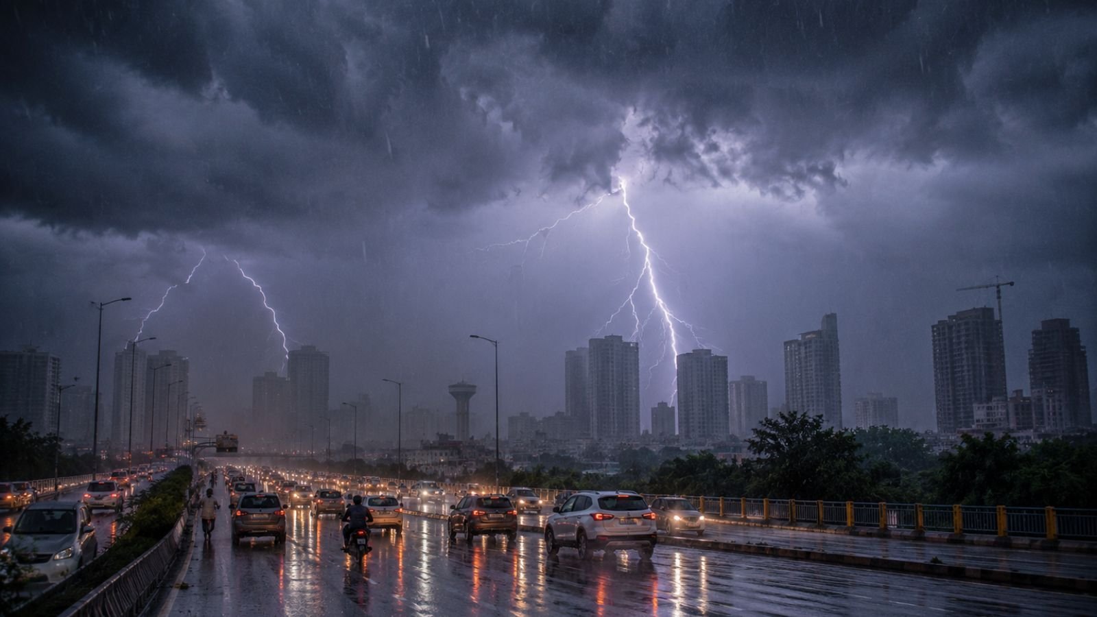
Heavy rain, thunderstorms, hailstorms, and strong winds have swept across Delhi NCR, bringing dramatic relief from the intense heatwave that had gripped the region over recent weeks. The sudden weather change has significantly lowered temperatures, improved air quality, and prompted the India Meteorological Department (IMD) to issue an Orange Alert for Saturday and a Yellow Alert extending into Sunday. The weather system has transformed conditions across Delhi and neighboring NCR regions, replacing scorching temperatures with widespread rainfall, gusty winds, and cooler weather. While residents have welcomed the drop in temperatures, authorities have also issued advisories regarding waterlogging, traffic disruptions, and severe thunderstorm activity.
Delhi NCR Witnesses Major Weather Shift
After days of extreme heat and uncomfortable weather conditions, Delhi NCR has experienced a significant atmospheric change. Widespread rainfall accompanied by thunderstorms and hail activity has affected multiple parts of the National Capital Region. The sudden weather event has resulted in a noticeable cooling effect, ending the recent spell of intense heat that had pushed temperatures to uncomfortable levels. The IMD has categorized the weather situation as significant enough to warrant alert notifications, urging residents to remain cautious during periods of heavy rainfall and thunderstorm activity.
IMD Issues Orange Alert for Saturday
The India Meteorological Department has issued an Orange Alert for Saturday due to active weather conditions across the region.
The alert comes in response to:
- Heavy rainfall activity
- Thunderstorms
- Hailstorm reports
- Strong wind gusts
- Possibility of localized severe weather events
Meteorologists continue to monitor the system closely as it moves across Delhi and surrounding NCR districts. The Orange Alert signals the need for preparedness and caution, especially for commuters, outdoor workers, and residents living in low lying areas.
Yellow Alert Continues Into Sunday
While the most intense weather activity is expected during the current phase, the IMD has maintained a Yellow Alert for Sunday. According to the forecast, cloud cover will remain widespread, scattered rainfall may continue, temperatures will stay lower than recent heatwave levels, and weather conditions are expected to remain unstable in some locations. The continuation of alert status indicates that weather impacts may persist even after the strongest storm activity weakens.
Delhi Weather Forecast June 2026
Heavy Rainfall Covers Large Parts of Delhi NCR
Rainfall has become one of the most significant features of the current weather system.
| Rainfall Parameter | Details |
|---|---|
| Type | Light to moderate across large sections, heavy in several districts |
| Intensity | 3 to 5 centimeters per hour in some areas |
| Extreme intensity | Cloudburst like conditions recorded at some stations, crossing 100 mm per hour |
These intense rainfall spells have contributed to rapid water accumulation in vulnerable urban areas.
Strong Winds and Hailstorms Add to Weather Impact
The rainfall has been accompanied by powerful wind activity.
- Wind speeds ranged from 40 kmph to 60 kmph across many locations, reaching up to 80 to 90 kmph in certain adjoining NCR regions
- Strong winds have damaged tree branches, increased risks from weak structures, and created visibility challenges for motorists
- Hail activity has also been reported from several parts of Delhi NCR
The combination of rain, hail, and strong winds has made this one of the most impactful weather events experienced in the region in recent weeks.
Temperatures Drop Sharply Across the Region
One of the most noticeable effects of the weather system has been the dramatic reduction in temperatures. The maximum temperature has fallen significantly and is now expected to remain between 34°C and 36°C. This marks a major improvement compared to the extreme heat experienced previously. According to available information, these temperatures represent Delhi lowest daytime maximum readings in approximately three weeks. For residents who endured prolonged heatwave conditions, the cooling trend has brought substantial relief.
Air Quality Improves After Rainfall
The weather event has not only reduced temperatures but has also improved environmental conditions. Heavy rainfall helped wash dust and airborne pollutants from the atmosphere. As a result, Delhi Air Quality Index (AQI) improved significantly, AQI levels reportedly reached 82, and the city entered the satisfactory air quality category. The improvement highlights one of the positive side effects often associated with widespread rainfall and storm activity.
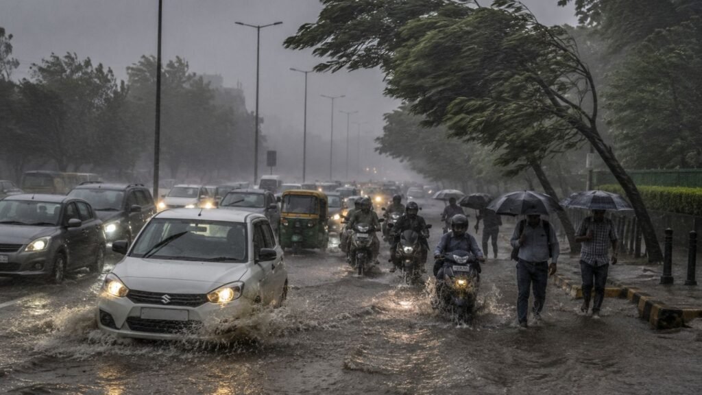
Waterlogging Creates Urban Challenges
Despite the welcome drop in temperatures, the rainfall has also created disruptions. Authorities reported waterlogging in low lying neighborhoods, major intersections, urban underpasses, and roadside drainage zones. Rapid rainfall accumulation has caused temporary traffic disruptions and slowed movement in several parts of the region. Urban flooding remains one of the primary concerns whenever intense rain falls within a short period.
Traffic Advisory Issued for Commuters
Traffic authorities have urged residents to remain cautious while traveling. The Delhi Police Traffic Cell has advised commuters to monitor real time route updates, avoid waterlogged roads, stay away from flooded underpasses, and delay non essential travel during peak thunderstorm periods. Drivers have been encouraged to exercise additional caution due to changing visibility conditions and the possibility of sudden weather deterioration.
Emergency Alert Notifications Sent to Residents
A notable aspect of the weather event was the use of emergency notification systems. Many residents across Delhi NCR reportedly received automated emergency warning notifications on their mobile phones. The alerts were issued as part of the government real time disaster warning infrastructure.
The emergency notifications aimed to:
- Inform residents about severe weather conditions
- Increase public awareness
- Encourage precautionary measures
- Reduce weather related risks
The use of mobile alert technology reflects growing efforts to improve disaster preparedness and public safety communication.
Coimbatore Weather Forecast June 2026
Why This Weather Change Is Significant
The sudden shift from extreme heat to widespread storms has created one of the most dramatic weather transitions of the season. The weather system has simultaneously reduced temperatures, improved air quality, increased moisture levels, triggered rainfall and hailstorms, and generated strong wind activity. For residents, the event demonstrates how rapidly pre monsoon weather systems can transform atmospheric conditions across northern India.
Impact on Daily Life
The weather has influenced multiple aspects of everyday activity.
- Positive Impacts: Residents have benefited from cooler temperatures, relief from heat stress, better air quality, and reduced exposure to extreme heat
- Challenges: Authorities continue to monitor traffic congestion, waterlogging, fallen trees, reduced road visibility, and thunderstorm related hazards
Balancing these benefits and challenges remains a key focus for local administration.
Weather Outlook for Sunday
The IMD forecast suggests that weather conditions will remain active, although less severe than the current phase. For Sunday, residents can expect continued cloud cover, scattered rainfall, cooler temperatures, and intermittent weather disturbances. The Yellow Alert indicates that caution remains necessary even as the most intense storm activity gradually weakens. Meteorologists expect temperatures to stay relatively comfortable before warmer conditions begin returning during the following week.
Safety Precautions During Thunderstorms
Authorities continue to advise residents to remain alert.
- Stay indoors during lightning activity
- Avoid sheltering beneath isolated trees
- Secure loose outdoor objects
- Keep electronic devices protected during severe storms
- Follow official weather advisories
Travelers should also allow additional time for journeys due to potential delays caused by rainfall and waterlogging.
Conclusion
Delhi NCR has experienced a major weather transformation as heavy rain, thunderstorms, hailstorms, and strong winds ended the recent heatwave conditions across the region. The IMD Orange Alert for Saturday and Yellow Alert for Sunday reflect the seriousness of the ongoing weather activity. While the rainfall has brought welcome relief through cooler temperatures and improved air quality, it has also caused waterlogging, traffic disruptions, and safety concerns associated with strong winds and thunderstorms. Authorities continue to advise caution as unstable weather conditions persist. With temperatures now expected to remain between 34°C and 36°C and scattered showers likely to continue into Sunday, residents can expect a temporary break from extreme heat before warmer weather gradually returns in the coming days.
Frequently Asked Questions
Q1. What alerts has the IMD issued for Delhi NCR?
A1. The IMD has issued an Orange Alert for Saturday and a Yellow Alert for Sunday due to heavy rain, thunderstorms, hailstorms, and strong winds.
Q2. How much did temperatures drop in Delhi NCR?
A2. Maximum temperatures have fallen significantly and are now expected to remain between 34°C and 36°C, representing Delhi lowest daytime maximum readings in approximately three weeks.
Q3. What was the wind speed recorded during the storm?
A3. Wind speeds ranged from 40 kmph to 60 kmph across many locations, reaching up to 80 to 90 kmph in certain adjoining NCR regions.
Q4. How did the rainfall affect Delhi air quality?
A4. Heavy rainfall helped wash dust and airborne pollutants, improving Delhi Air Quality Index (AQI) to 82, placing the city in the satisfactory category.
Q5. What safety precautions are advised during thunderstorms?
A5. Residents should stay indoors during lightning, avoid sheltering under isolated trees, secure loose outdoor objects, keep electronic devices protected, and follow official weather advisories.